Tarek Zohdi Computational Manufacturing and Materials Research Lab, UC Berkeley
Fall 2019 – Spring 2020
Skills
Computer: MATLAB, Python, Video Editing
Language: Technical Writing, Public Speaking
Team
Masters Capstone Group of Three (Industrial/Mechanical Engineering)
Award
Honorable Mention: MEng Alumni Award for the Most Innovative Project
Project Summary
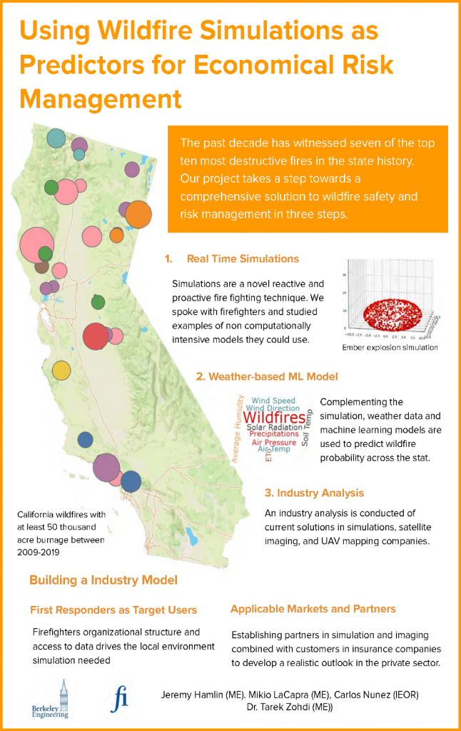
Wildfires have become a yearly occurrence in the state of California, repeatedly unraveling communities and causing widespread adverse health effects. The past decade alone has witnessed seven of the top ten most destructive fires, including the deadliest Camp Fire. Motivated to find new outlooks on safety and liability, this project assesses fire technologies in the 21th century by exploring the feasibility of developing or acquiring a wildfire predictive tool, as well as identifying key partners and customers in several markets. This search was primarily conducted within the context of the risk assessment market, which a business analysis exposed as accessible and profitable. Proposed is a combination of a fire prediction model based on demographic and climatological variables attaining 60.3% accuracy, and a Monte Carlo simulation to calculate premiums in a fair manner for both insurance companies and homeowners. Wildfire simulations compared to design criteria as well as future computational directions were also explored.
Background
A jaded perspective of a new reality where California wildfires are a yearly epidemic is exacerbated by the fact that 2009-2019 (hereby referred to as the past decade) have been witness to a majority of the state’s worst individual wildfires since it started keeping track in 1932. Notably seven of the most destructive and half of the largest have occurred within this ten year period. There are compounding causes to this issue including, rising temperatures and increases in atmospheric vapor pressure deficit defining seasons towards producing arid conditions, historical fire suppression practices which have led to increased species homogeneity, tree density, and the continuous surface fuels, and finally the increasing number of individuals who are living between urban and forest areas.
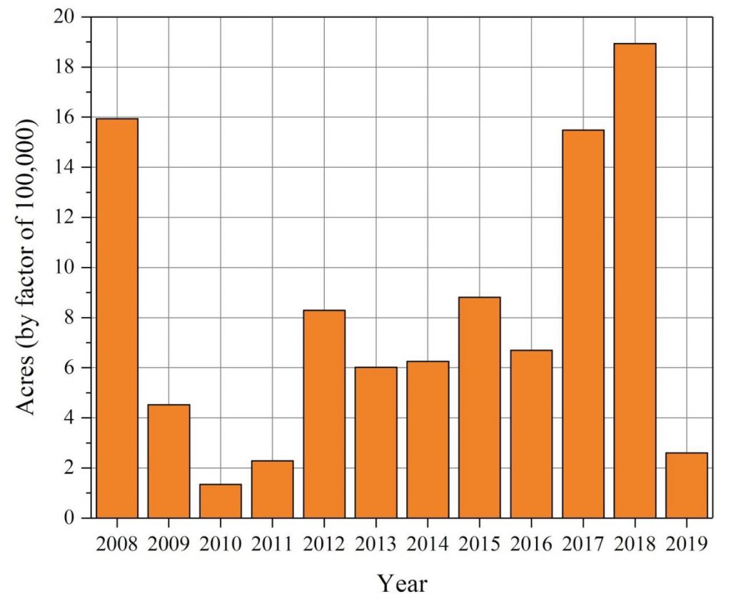
Acres burned in California from wildfires between 2008 and 2019
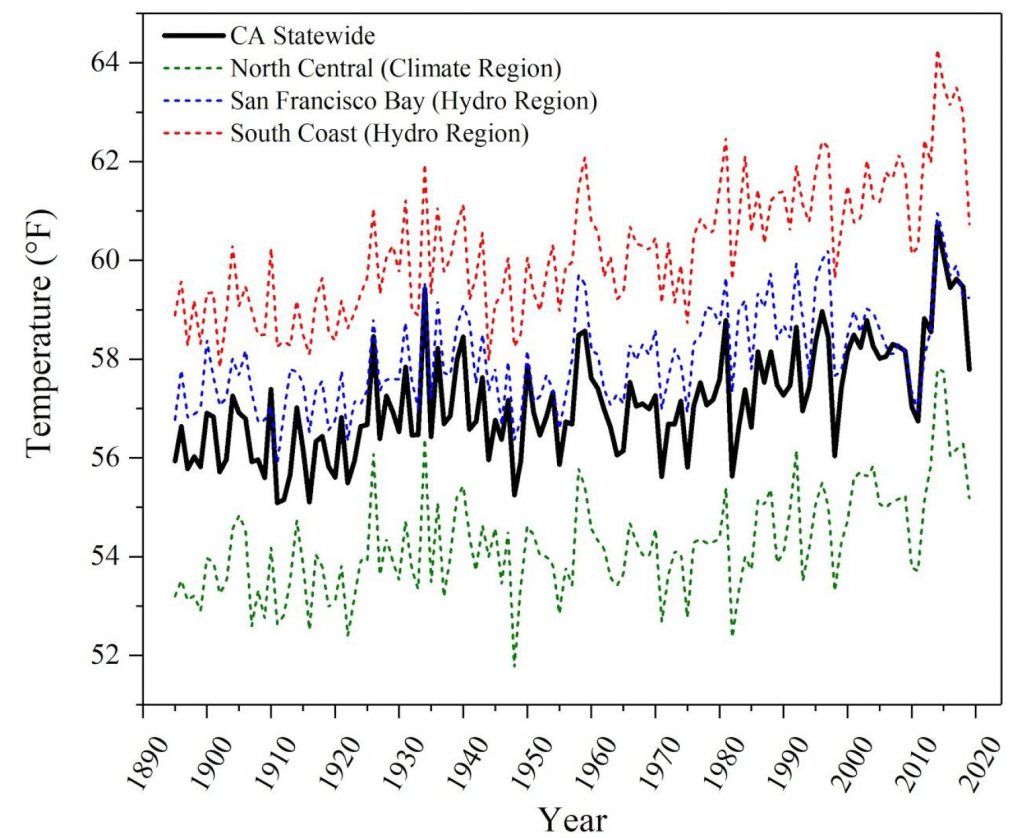
Average annual temperatures for the state of California, North Central Climate Region, San Francisco Bay Hydro Region, and South Coast Hydro Region from 1895-2015
This projects focuses on three stakeholders while acknowledging the challenge of singling out groups among those affected by wildfires both emotionally and financially, and ranging in size from the state to the individual. The first stakeholders identified are first responders, such as firefighters who face unpredictable danger, long term health risk, and ethicacy concerns surrounding prison labor. The next group are home owners who poses a risk on both the ignition and destruction sides of the wildfire crisis. Finally, while not often mentioned, insurance adjusters are also a key player since inaccurate or incomplete historical or predictive information, leads to a loss of millions of dollars when arbitrarily setting rates.
My Role
My role on the project was heading the computational study in order to gain an understanding of the limits of computational power and accuracy in real time prediction. I investigated current USDA programs such as FlamMap, FARSITE, and Behave, and compared them to design criteria determined from firefighter user research. An important constraint is the incident wide communication structure, which primarily relies on 12 to 24 hour intervaled meetings. I found that adopting FARSITE’s spacial, temporal, and rediscritization strengths while providing an inclusive service or easing access to landscape environmental files, would be a strong market entry strategy for simulations conducted at fire stations. Start ups such as Technosylva have taken this approach.
I also investigated two alternative simulation methods: an particle based model of ember lofting and celluar automata, developing simple models in each based on Dr. Zodhi of U.C. Berkeley and Wang-Zhengfei model. Both methods struggled for being too computationally taxing or reliant on specific observations variables to be currently practical. However, the cellular automata model acted as a proof of concept for using simulations in a Monte Carlo method to estimate likelihood of burn for a specifically located house, which could be paired with historical data to determine insurance premiums.
Lastly in the simulation direction, I highlighted promising future directions such as developing a model for secondary dangers, such as from slow burning houses causing crowing, and building unique AI models from historical wildfire data and paths, as was done in the new FireCast program.
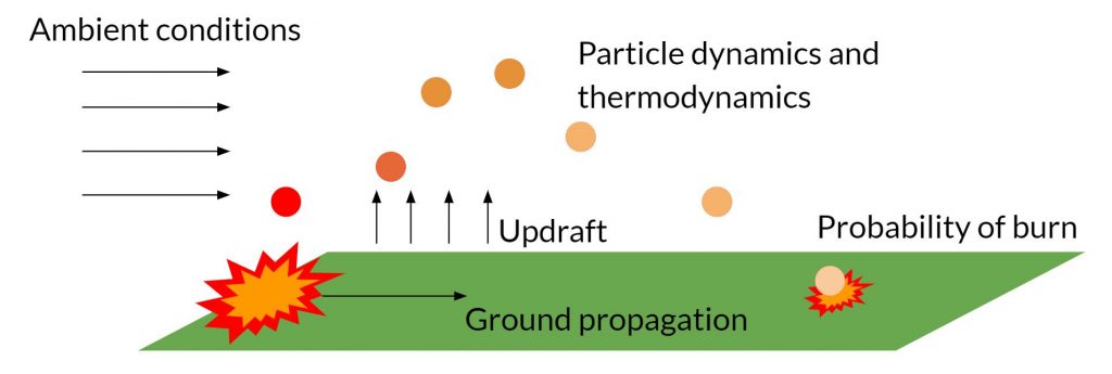
Schematic of the particle based method of representing fire growth due to ember lofting and ground propagation.

Two example wildfires growths from a single random ignition point after a standardized time period across variable terrain with fire breaks. Burn percentages of specifically located houses are highlighted.
One of the largest challenges this capstone faced was having a widest breathe problem statement, meaning there were numerous self-guided directions this project could have taken. Through conversations with advisors and stakeholders, I was able to identify a unifying theme for all team members’ strengths and practice project management principles to achieve our final product.
Other Project Directions
Other directions which I assisted in with my gained knowledge of the simulation field included an industry analysis and development of a predictive model using historical data and machine learning. Market research into the feasibility of in-house computation versus outsourcing, for technologies such as mapping digital twins of environments, revealed a business with insurance companies and wildfire prevention organizations as customers could thrive with minimal competition, low threat of substitutes, and low barriers to entry. The predictive machine learning program used 66,466 California fires and daily weather conditions between 1992 and 2015 to estimate the probability of a fire starting in a given location. The XGBoosting tree-based ensemble model achieved the greatest accuracy. This probability is of interest to insurance companies when paired with a Monte Carlo simulation of given area to determine the likeihood of a house burning down given the probability of a fire occurring.
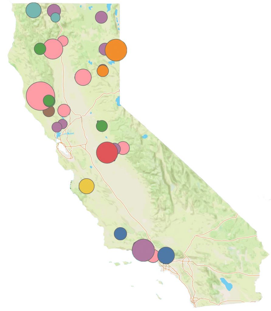
Map of fires with burnage over 50,000 acres in the past ten years (2009-2019) colored by year
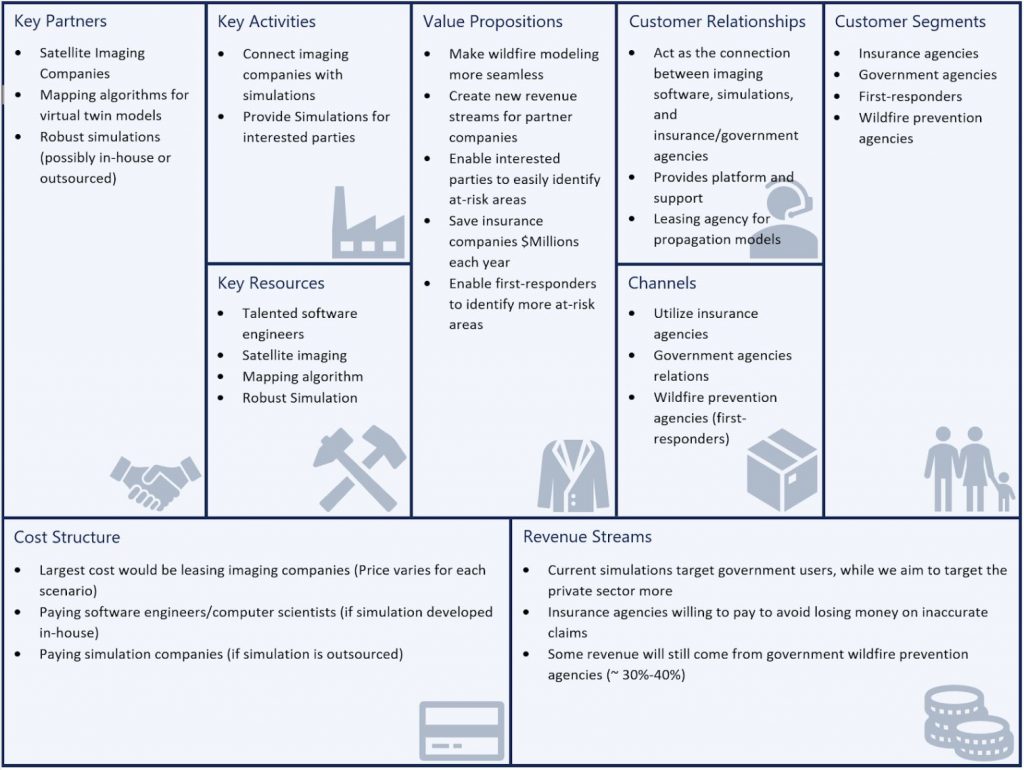
Business model of proposed data provider for insurance and government agencies
Deliverables
Deliverables of this project included a presentation (YouTube) for a Mechanical Engineering Masters Capstone Exam, final report, and project overview poster (below). The project was awarded an honorable mention for the MEng Alumni Award for the Most Innovative Project. This award was significant for me since it mirrored my motivation as an engineer to apply my problem solving skills for societal benefit.
